- As a proxy for vegetation photosynthetic activity, vegetation indices (VIs) were estimated from the
visible to near-infrared, i.e. VIS-NIR, spectral bands from remote sensing images.
- Sentinel-2 Level-2A (S-2A) images we collected using the Google Earth Engine (GEE) cloud computing
platform. For now, we have considered scenes within the period from January to December 2021 without
cloud filtering. The clouds were later masked and the images co-registered as image collections.
- In an exploratory analysis of vegetation cover, 5 different vegetation indices (VIs) were computed
and stacked for processing and analysis.
- As no ground truth data is yet available for the period of exploratory analysis (2021), we applied
an unsupervised image classification procedure was applied.
- This classification experiment hypothesised a combination of VIs to provide complementary
information and features to enhance thresholding of vegetation and land cover types. Nonetheless, for
VI-based classification, it is inappropriate to assume similar vegetation class thresholds for all VI
types - the widely applied thresholds may not be optimal for all VIs, vegetation types and context.
- The K-means clustering algorithm was applied with 5 clusters selected based on visual observations
from the classes obtained by VI thresholding.
- On this basis clustering results, we applied five thresholds of potential vegetation classes (<
0.2: No Vegetation, 0.2 – 0.3: Low vegetation, 0.3 – 0.4: Sparse vegetation, 0.4 – 0.5: Moderate
vegetation, and > 0.5: Moderate-High vegetation).
- Image thresholding procedure and unsupervised classification (image clustering) were conducted using
the GEE cloud computing platform and the resultant images exported as Geo Tiff files for further
(supervised) analysis.
K-Means Clustering Silhoutte Metric
Heirarchical Cluster Analysis Dendrogram
Jaccard Similarity Index Analysis of Clusters
Vegetation cover classes for Wadi Ashar according to thresholds of different vegetation indices
(VIs): a. NDVI b. EVI, c. SAVI, d. MSAVI, and e. GSAVI
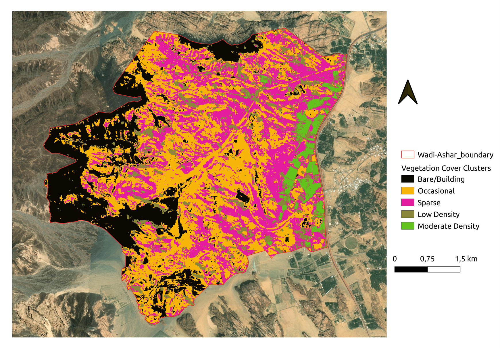
The vegetation classes from unsupervised (K-means clustering) classification of time-series images
of 5 VIs