Welcome to my blog on several projects at the nexus of Data Science and Earth Observation & monitoring of Vegetation cover and land use.
Recent Projects
Project 1: Cocoa Agroforestry Land Use Classifier
- Developed a classifier procedure for discriminating perennial cocoa agroforestry land cover.
- Compared a multi-spectral optical image from RapidEye, acquired in the dry season, and multi-seasonal C-band SAR of Sentinel 1.
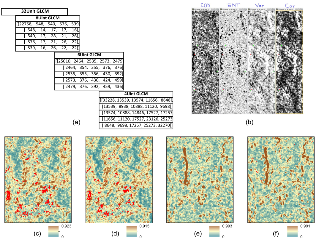
- Hand engineered Grey Level Co-occurrence Matrix (GLCM) texture features (images) from Sentinel-1 Image time series covering six dry and four wet seasons from 2015 to 2017.
- Optimised Random Forest Ensemble classifier models using different input feature combinations; multi-spectral reflectance, vegetation indices, co-(VV) and cross-(VH) polarised SAR intensity and GLCM texture measures.
- Evaluated accuracy metrics and uncertainty Shannon entropy - information loss in classification.
- Built a classifier and uncertainty measures that provide reliable validation of class discrimination at different spatial resolution.
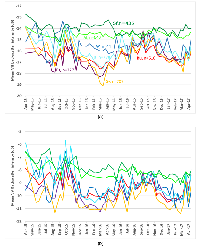
SAR Backscatter Time-series over different land uses
Sentinel-1 SAR GLCM Texture-Based Discrimination of Cocoa Agroforestry land use
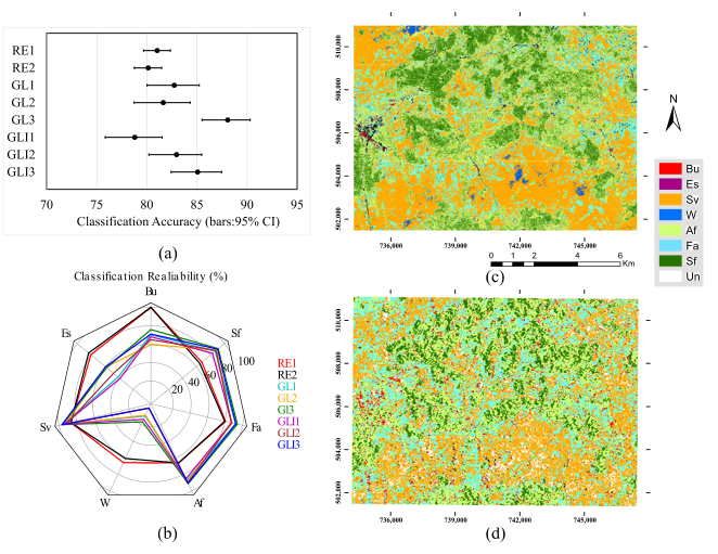
Land use classification compared for Sentinel-1 SAR and Rapid-Eye

Project 2: Cocoa Agroforestry Canopy Gap Predictor
- Estimated canopy cover distribution using in-situ digital hemispherical photographs (DHPs) sampling and estimates of canopy gap fraction.
- Built neural network and random forest regression models of cocoa agroforestry canopy gap fraction and Sentinel-1A SAR backscatter intensity and features.
- Developed a combination of different backscatter variables for predicting the canopy gap variability in agroforestry cocoa production landscapes.
- Utilise a semi-variogram analysis of canopy gap distribution and spatial clustering distances in different cocoa production landscapes.
- Provided new insights into the scale of spatial variability of canopy gaps in relation to farm and landscape management through cocoa agroforestry land use.
- Built a proof-of-concept to support development of management tools or strategies on tree inventorying and decisions regarding incentives for shade tree retention and planting in cocoa landscapes.
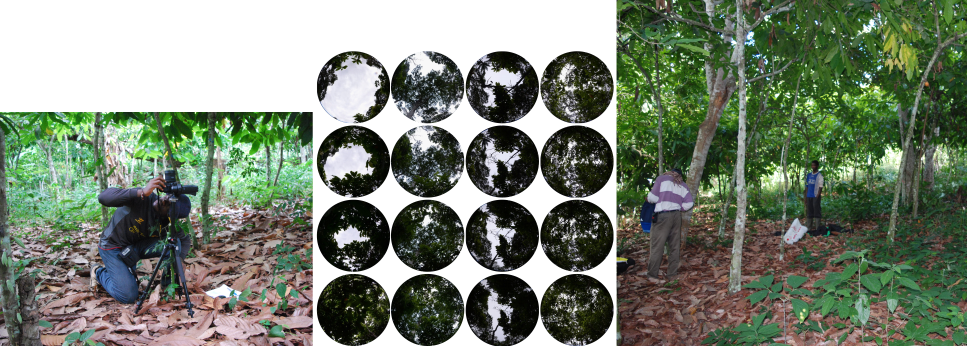
Inventory of canopy cover distribution (ground truth)
Field and spatial data analysis workflow
Project 3: Estimator of Tree Spatial Pattern in Agroforests
- Assessed the temporal changes in shade management and spatial dynamics in canopy tree structure and live tree biomass.
- Conducted field survey along an age gradient of “family farms” in cocoa agroforests created from forest (fCAFS) and savannah (sCAFS) land cover.
- Evaluated the temporal changes in farm structure, relative tree abundance, and live aboveground biomass of the major canopy (shade tree) strata.
- Used spatial point process and linear mixed effect analyses to assess contributions of associated perennial trees (AsT) on farm rejuvenation patterns.
- Provided insights into farmers’ temporal allocation of uses and prioritization of different tree species associations with age of cocoa agroforests.
- Developed recommendations for landscape-specific tree management and considerations in proposing on-farm tree conservation incentives.
Spatial sampling and point pattern analysis steps
Spatial pattern of cocoa trees across farm type and age gradients